


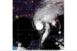
Isaias strengthened into a major hurricane Friday as it headed toward the U.S. Gulf Coast, where final preparations were underway for potentially life-threatening storm surges and high winds.
Meanwhile, Hurricane Simon was headed toward Mexico’s Pacific coast and forecast to strengthen significantly. U.S. forecasters issued a hurricane warning for parts of the central and southwest coast, where hurricane-force winds were expected within 36 hours.
Tropical storm activity has been above average this season in the Pacific because of a strong El Niño, a natural, temporary warming of parts of the Pacific that warps weather worldwide. In the Atlantic, El Niño’s decapitating winds and the Gulf of Mexico’s toasty, storm-fueling waters are battling over Isaias’s future strength.
Here's the latest:
DeSantis requests an emergency declaration
Florida Gov. Ron DeSantis on Thursday requested an emergency declaration which, if approved by President Donald Trump, would authorize federal support for the state’s emergency protective measures.
Atlantic hurricanes starting with ‘I’ typically bring death and destruction. Isaias is up next
Be wary of hurricanes that start with the letter “I.”
The ninth letter of the alphabet leads all others in the number of named Atlantic storms that have been retired over the decades due to their destruction or high death tolls. The names may be out of circulation, but storms including Ian, Ida, Igor, Ike, Inez, Ingrid, Iota, Irene, Irma, Isabel and Ivan left lasting legacies.
Next up is Isaias, which became the first hurricane of the Atlantic season Wednesday night. Whether it lives up to the misery of others whose first letter it shares remains to be seen. The latest forecast suggested Isaias could be less dramatic, but still “extremely dangerous.”
“It’s the ‘I’ storm, which usually we have a lot earlier in the year,” said Kristen Corbosiero, a professor of atmospheric and environmental sciences at the University at Albany. “It’s always the ‘I’ storms that seem to cause problems.”
▶ Read more
FEMA says its staff is ‘fully engaged’
The Federal Emergency Management Agency urged Gulf Coast residents on Thursday to prepare for the hurricane and said that its offices were “fully engaged.”
FEMA staff were embedded in state emergency operations centers and incident management teams deployed to Alabama and Florida. The agency prepositioned emergency supplies at Maxwell Air Force Base in Montgomery, Alabama, and has activated multiple national urban search and rescue teams “for potential movement if needed.”
Disaster response is led by local and state jurisdictions, with FEMA in a supporting role to coordinate federal support as needed and requested.
El Niño’s storm-killer winds and climate’s warming waters are in a fight over Isaias’ future
A supersized El Niño’s decapitating winds and the Gulf of Mexico’s toasty, storm-fueling waters are battling over the future strength of Hurricane Isaias. And the storm’s tilt and eye show who’s winning.
For now, it’s the waters charged by climate change.
All Atlantic hurricane season, there has been “this battle between shear and just the overall conducive conditions,” said Colorado State University hurricane researcher Phil Klotzbach.
El Niño — the natural temporary warming of parts of the Pacific that warps weather worldwide — dominated. Its wind patterns smothered almost any wisp of a storm from strengthening in the Atlantic, while boosting what will soon be record-high levels in the Pacific, Klotzbach said.
▶ Read more
Gov. DeSantis warns of significant storm surge and wind damage
At a Friday morning news conference, Florida Gov. Ron DeSantis warned of significant storm surge and likely wind damage.
“But the surge is really what puts a lot of people’s lives in jeopardy if they haven’t heeded evacuation orders, and does the most significant damage from these storms,” he said. “Everywhere from Pensacola all the way into the Big Bend section of north Florida, you could see storm surge. So please take caution of that.”
He added, “And we always say you hide from the wind, but you run from the water. When the water’s rising and things are happening, it’s a very, very difficult conundrum — and you do not want to be caught in that.”
Shelters are opening for residents along the US Gulf Coast ahead of Isaias
Some areas, including several counties in the Florida Panhandle, are under mandatory evacuation orders. Alabama Gov. Kay Ivey has told tourists and visitors in the state’s coastal areas to leave immediately.
There are three shelters opening Friday morning at schools in Mobile County, Alabama. At least four churches in Dothan, Alabama, are being offered as shelters Friday, and they’re even providing snacks and drinks. The Red Cross has opened overnight shelters in the Florida panhandle, including one at Northwest Florida State College’s arena.
Isaias is forecast to make landfall late Friday.
Isaias strengthens into a dangerous Category 3 hurricane on track toward the US Gulf Coast
Isaias strengthened Friday into a major hurricane as it headed toward the U.S. Gulf Coast, where final preparations were being made for potentially life-threatening storm surges and high winds.
The hurricane is forecast to make landfall late Friday somewhere along the Alabama-Florida line and create dangerous conditions in the Florida Panhandle, southern Alabama and southern Mississippi, the National Hurricane Center said. Rain began falling along the coast Friday morning, and tropical storm conditions were expected to begin early in the afternoon.
The Category 3 storm was packing 120 mph (193 kph) winds and was expected to continue strengthening. Category 3 storms, considered major hurricanes, are capable of causing devastating damage, the center said.
Isaias was expected to weaken quickly as it hits shore and be downgraded to a tropical storm by Saturday afternoon as it moves north and inland along the Alabama-Mississippi line, the center said.
Read more
...